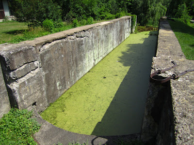
The Cuyahoga River Valley winding it's way approximately 40 miles between Cleveland and Akron Ohio is great place to enjoy nature and soak in some history from Ohio's early statehood. The key historical feature of this area is the evidence of 44 locks that were used to raise and lower canal boats the 395 feet in elevation between Cleveland and Akron.
The Northern end of the Ohio & Erie Canal was completed in 1827. The final 300 mile stretch south to the Ohio River at Portsmouth was reached in the the 1830's. The canal was the young state's first infrastructure and was the key catalyst to Ohio's early economic and industrial growth. The opening of the canal also provided the final link in a waterway leading from the Great Lakes all the way to the Gulf of Mexico.
The Parks Service maintains a twenty mile stretch of the canal way and surrounding natural areas known as the Cuyahoga Valley National Park. The unique feature is the crushed limestone towpath that visitors can hike or bike. This is the very same path that was used by draft animals to tow the canal boats laden with goods to and from market.
I knew I was in for a long day on the bike so I rode the recumbent. The crushed stone surface while relatively smooth was marked with occasional bumps and erosion irregularities so the full suspension of my bike was welcomed. However I did spot all types of bikes on the trail from road to mountain and even a recumbent trike rider I encountered near Cleveland.
On average the locks would raise the boats about nine feet although one lock appropriately named deep lock elevated a whopping 17 feet. In many of my photographs the lock structure appears to be cement. The concrete was added in the early 1900's and covers the original building blocks hand hewn from local sandstone quarries.
For most of the canal way the towpath is nothing more than a strip of high ground between the canal and the Cuyahoga River. The Cuyahoga was the water supply for the canal and a clever system of feeders and water control gates were utilized to fill and drain sections for repairs.
Water Control Gate
The Cuyahoga river twists and turns like a serpent and at lock 29 the canal and the river crossed paths. In the picture below is a bridge with arched sides. This bridge crosses the Cuyahoga where it is constricted to a narrow channel constructed from the same blocks used to build the locks. An aqua duct constructed of wood and steel carried the canal boats over the river.
View looking down into the river channel from the bridge. This would be the same view that passengers on board the canal boats would have seen as they passed over the aqua duct.
In the visitors center I found an excellent replica of the stern section of a typical canal boat and some great old photos depicting life on the canal.
The canal was owned and maintained by the state but the boats were operated by private captains who lived with their families aboard the boats.
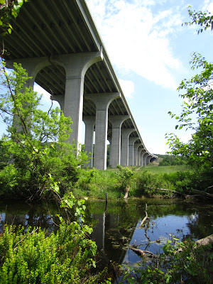
As lost in time and nature as I felt riding along the green pathway in the valley large spans overhead remind that progress marches on.
Many sections of the canal look like this with nature slowly reclaiming the man made channel once 40 feet wide by 4 feet deep. Other parts are completely overgrown with nothing more than a dry linear depression through the woods.
This trip was a great way to spend a Friday afternoon and it did not feel like 5 hours on the bike at all. I really felt great and wished to ride more but it was nearing six o'clock and I still had an hour drive in the car to get home. The Cuyahoga Valley is a magical place full of natural beauty and history nestled right in the middle of Ohio's oldest and largest industrial complex.
Friday Ride -- Ohio & Erie Towpath Trail
Bike: HP Velotechnik Street Machine
Ride Time: 4:59:34
Distance: 62.04 Miles
Average Speed: 12.4 mph
Max Speed: 27.1 mph


Interesting and quite ingenious. This desert rat knows little about canals.
ReplyDelete60 miles of flat terrain...paradise for a biker!
ReplyDeleteMakes me think of the C and O Canal from Washington DC to Cumberland Maryland. (also a great ride)
Wow, all the great history in your posts really make me want to take a trip to Ohio!
ReplyDeleteThanks for the comments. I thought this trip might make a blog-worthy post. I'd been planning the ride for a year now. Been 5 years since I was last up that way.
ReplyDeleteI checked this post out like you said. Great bit of history and fantastic pictures.
ReplyDeleteI'm a native of the Cuyahoga Valley, Summit County Historian, (akronhistory.org) and a frequent flyer on "The Towpath." Your post was well written and informative. Glad you enjoyed yourself and hope you come back soon.
ReplyDeleteThanks Rudy! The Towpath is a great ride.
Delete